 |
||||||||||||
 |
||||||||||||
 |
||||||||||||
Current and Recent Projects Include:
(Click here for a printer friendly PDF)
Building Bridges: Linking “Barefoot Journalists” with Key Stakeholders to Help Resolve Land Issues
One significant obstacle to the sustainable evolution of our planet is the way that people manage land. This situation is not new. What is new is the potential to use communication and social networking technology to give voice to community experiences concerning land issues.
The other condition that has changed is that the international community of professional practice around land tenure and use—professional associations, NGOs, researchers, geographic information systems experts, and educators--is now much larger and more accessible than ever before.
A communications gap exists, however, between local communities and the professionals committed to their positive evolution. The Building Bridges program helps overcome this gap.
Terra’s Building Bridges (BB) program is developing a set of activities in partnership with Community Support Organizations (CSOs) and Community Based Organizations (CBOs) to define, test, evaluate and extend a methodology to strengthen linkages between communities and key stakeholder organizations.
The first pillar of the “bridges” program is the production of communication clips by trained “barefoot” journalists who are members of communities and are concerned with land issues and other community achievements and needs. “Bridges” aims to assure authentic and accurate community representation and significant involvement in all of the phases of the message production process.
The second pillar in BB is the identification of potential subscribers for these clips who work in key stakeholder organizations relevant to the development of communities, including governmental agencies, regional and national NGOs, the local and national press and academic institutions, and extending to international development organizations, press, academic institutions, and international NGOs.
These two pillars are being connected via social media (e.g., YouTube, Blogs, etc), workshops, conferences and publications.
Terra has launched BB in Zambezia Province, Mozambique, with ORAM. By January, 2010 there will be four “barefoot journalist” working in Zambezia. By the end of 2010 the goal is for there to be 22 such journalists. BB is also underway with the Menominee Nation, Wisconsin, and is about to begin with CSO partners in India, Georgia, Peru and Afghanistan as funding becomes available. The International Land Coalition and the Huairou Commission are providing advice and guidance. We expect other community oriented organizations to join BB soon.
The Building Bridges program is currently being piloted and self-funded by Terra Institute. Funding sources are being contacted throughout the world to help support this effort. If you or your organization is interested in providing program support or if you require more information please contact David Stanfield at Terra Institute: jdstanfi@terrainstitute.org or +(608) 767-3449
ETHIOPIAN
GRADUATE PROGRAMS IN LAW FOR TEACHING AND RESEARCH CAPACITY BUILDING (US$1,669,693)
This is a five-year project implemented by the University
of Alabama – Tuscaloosa and the Ethiopian Justice and Legal System
Research Institute (JLSRI) in Addis Ababa, with Terra Institute providing
technical and administrative support.
Despite the significant role of Ethiopian legal education and the ongoing
reform efforts to enhance its capacity in all areas, there still are several
challenges that need to be tackled. There is a lack of courses consciously
designed to emphasize the centrality of good governance, democratization,
economic development and social justice and other constitutional values.
There is only one postgraduate program in law which is offered by Addis
Ababa University located in the capital Addis Ababa. Hence the fair distribution
of the program with all its benefits to the rest of the regions is yet
to be attained. The limited scope of the program and the number of graduates
hardly meet the country’s need for qualified and competent professionals
and researchers. There is insufficient ability to support and build the
capacity of other law schools and to supply teachers with the requisite
competence and standard in sufficient numbers. The JLSRI in Addis Ababa
desires the capability to engage and deliver research outputs that offer
tangible solutions to the needs of the government, private sector and
communities at large.
The project envisions the design and conduct of LL.M and LL.D programs
which are relevant to the needs of Ethiopia and aims at building the capabilities
of the existing law schools and legal research institutes in the country
by developing their teaching and research staff, and by putting in place
appropriate organizational structures as well as processes and procedures
and good practices in order to enable the law schools to launch and run
post graduate programs in law on their own.
The key tasks of this five year project will include: producing a preliminary
study on the need and priorities, designing LL.M and LL.D curricula and
academic programs, organizing the programs, conducting an LL.M program
for 40 (forty) students and an LL.D program for 18 (eighteen) students,
setting up procedures, processes and structures including the administration
and financial system regarding the academic programs, organizing required
teaching resources (books, databases and others), assigning the required
academic staff and researchers for the program and following up processes,
performance and achievements until such systems and procedures are fully
operational to the level of acceptable standards, mentoring counterparts
for capacity building towards future graduate programs in law, and managing
the program jointly with Ethiopian counterparts.
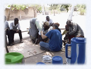
Terra’s Media Specialist, Mark Anthony Rolo
shows potential “Barefoot Journalists” how to
use a video camera
Abdulmalik Abubaker, Faculty of Law Dire Dawa University College (Ethiopia) and Dr. Norman Singer, Faculty of Law University of Alabama
SECOND RURAL INVESTMENT AND SERVICES PROJECT IN MOLDOVA (RISP II) (US$556,190)
Moldova has made impressive progress in land reform since the introduction of the National Land Program in 1998-1999. Formally, land privatization started in 1992, however the land was not physically distributed to the farmers but rather they were given a share in the collective farm. Private land ownership rose from practically zero in 1998 to 67% of all agricultural land, and physical plots have been allocated to more than one million rural people. The previous steep decline in agricultural production halted and growth has resumed. However part of the agricultural land is used by large corporate farms, heirs of the former collectives. The agricultural land which was distributed to individual household members is frequently segmented in different locations. These allocations might also vary by land type such as a plot of arable land here, a plot of vines somewhere else, and an orchard in a third location. Land was also distributed to virtually all rural residents regardless of their interest or experience with farming. While studies indicate that the small private household farms are significantly more efficient than the large corporate farm, the small size of plots and their fragmented nature has a negative impact on the overall agricultural productivity. The current system makes it extremely expensive and time consuming to trade parcels so that one household owns adjacent or convenient parcels. One goal of RISP II will be to simplify the process and cost of buying, selling, or leasing agricultural parcels.
RISP II which began on August 1, 2007 has five components: Rural Advisory Services – to provide information, knowledge and know-how to newly established private farmers and rural population; Rural Business Development Services – to strengthen the emerging rural private sector by financing technical assistance to rural entrepreneurs, and operational support for local development agencies; Rural Finance – to continue to expand the outreach of the formal financial sector to rural areas, to ensure broader access to investment financing for farmers and rural entrepreneurs, to strengthen the Savings and Credit Associations and provide financial services to a large segment of the population which does not have access to traditional banking services; Land Re-Parceling Pilots – to respond to the concerns of Government and others about the fragmentation of agricultural land by facilitating the efficient functioning of land markets in pilot locations through the implementation of village voluntary land re-parceling projects based on international best practice; Project Management – to provide technical and financial support for project management.
Under a grant from the International Bank for Reconstruction and Development, and financing by the World Bank and Swedish SIDA, and in partnership with NIRAS AB, Sweden, Terra Institute will assist the Government of Moldova with implementation of Component #4. Terra Institute will be providing the Land Management Expert who will be largely responsible for planning and carrying out the pilot projects in the six villages, focusing on small peasant farmers as its primary target group. The specific objectives of these pilots are to: (i) test the demand for and feasibility of land re-parceling with small landowners as the primary target group; (ii) use the pilot experience as the basis for designing a potential national-level approach, including techniques, resource requirements and legislative framework; and (iii) assess the impact of re-parceling at the local level, on land markets, agricultural production, and equity.
Six different sites representing different regions with different agricultural and land market conditions will be selected. Landowner participation in the pilot projects will be strictly voluntary and land re-parceling will focus on improvement of individual land holdings, not on creation of larger farms. In addition, measures will be taken to ensure there are no adverse environmental impacts.
When project objectives are met, this will enable the Government of Moldova to continue to foster post-privatization growth in the agricultural sector by improving access of new private farmers and rural businesses to what they need to succeed – legal ownership status, knowledge, know-how and finance. The project will also continue to implement policy, legal and regulatory reforms, institutional capacity-building, technical assistance and investment support. The project will also gradually transfer responsibilities to the appropriate government agencies, and build capacity of these agencies to ensure long-term institutional development and sustainability.
The first land re-parceling agreement signed bylandowner in Calmatui, Moldova (April 2008)
(US $30,304)
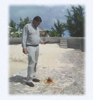
The product of this ten-week consultancy, December 10, 2007 through February 25, 2008, conducted by Dr. J. David Stanfield, was a case study documenting how land issues were addressed following a sudden-onset natural disaster, Hurricane Katrina, which flooded New Orleans, USA in 2005. UN-HABITAT, with support from the Food and Agriculture Organization (FAO) and the United Nations Development Programme (UNDP), is developing a set of clear, simple guidelines for addressing land issues in the aftermath of natural disasters, based on seven case studies of natural disasters worldwide, such as the 2004 Indian Ocean tsunami and the 2005 Pakistan earthquake. The guidelines will be supported by a toolkit of proven tools and methodologies to support implementation in the field.
When Dr. Stanfield agreed to produce this case study, he found he had underestimated the vast amount of literature and discussions which had already emerged on the effects of Hurricane Katrina. However the wealth of information proved to be very fortunate, leading to a meeting of a number of experts to discuss the objectives of the seven case studies and how different people viewed the impacts of Katrina on land issues in New Orleans. One outcome of the discussion was the decision to only partially address the wetlands restoration theme, which is vital to the survival of New Orleans, since the storm surges are more violent today due to dramatic loss of wetlands separating the city from the sea. It was recommended that this topic be explored more adequately in a separate study.
The case study deals with the effects of a tremendous hurricane on land and property in a well established city which is also a port facility and a cultural center in the United States. The storm produced extensive damage to homes and businesses all along the Gulf Coast, and the displacement of over 1 million people.
The storm also produced concerns for the unique property records administration system, particularly in New Orleans. Due to its long history, New Orleans has property record archives dating back to 1825. Also due to that long history, property records have been recorded by multiple agencies, in varying formats. Another issue was that some records stored in basements were water-damaged. After the storm, as these multiple agencies scrambled to move their records and reopen their offices to the public needing property records for many recovery reasons, inefficiencies and incompatibilities among these multiple agencies and methods of organizing documents became glaringly apparent.
While extensive resources have been mobilized to deal with the land issues exposed by this disaster, the case study makes the point that the issues involved are directly comparable to those faced by other citizens and government agencies in other countries dealing with other kinds of natural disasters. Of particular importance in the Katrina case and other cases is the influence of politics on the recovery. In the Katrina case, the political forces favoring the privatization of public services and the reliance on private markets for guiding investment decisions, in a context of historic racial tensions, resulted in dramatic failures to meet the needs of the hurricane displaced and damaged populations, particularly the poorer segments of society.
The results of the seven case studies were presented at the UN-HABITAT Conference in Geneva, Switzerland April 11-24, 2008 where Dr. Stanfield delivered his paper on Post-Katrina.
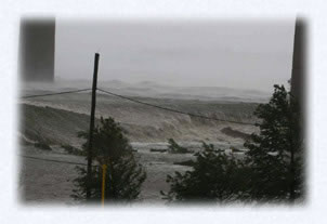
Hurricane Katrina devastates the City of New Orleans, LA in August 2005
In 2005, the Turks and Caicos Islands Government (TCIG), with the assistance of Terra Institute, completed a comprehensive study on Crown Land Management which examined the current Crown land policy and produced recommendations for a future comprehensive approach which maximizes sustainable revenues from Crown Land, takes account of competing economic, social and environmental factors, benefits the long term economic and social interests of the Belonger Community and ensures transparency and openness in the administration of Crown land. (See Terra’s Past Projects for a description of this study and a link to the report.)
As a result of the recommendations from this study, in November 2006 the TCIG approved a new Crown Land Policy which states 21 key principles and actions related to Crown land. Under this new project the TCIG intended to take the required technical, institutional and legal steps to fully implement this Policy through the Ministry of Natural Resource, Planning and Environment. For this the Ministry required the services of a consulting firm with previous experience in assisting governments in developing and implementing land policy, specifically in respect to the sustainable management, allocation, regulation and pricing of government-owned land. Terra Institute was chosen by the Ministry to carry out this Crown Land Implementation Consultancy which was designed to assist the TCIG through the Ministry of Natural Resources in completing the design, development and initiation of urgent aspects of a Turks and Caicos Crown Land Management Project which is intended to finance and guide the full implementation of the Crown Land Policy over an estimated two year period of time.
This project was carried out by a team of five specialists with significant experience in the institutional, technical and legal aspects of development and implementation of land policies. This team approach allowed for the various disciplines required to be covered and also provided for exchange of ideas between land and property specialists that will result in a more comprehensive product for the Ministry of Natural Resources. In their Final Report, the team delivered the following to the TCIG:
1. A comprehensive Institutional Report on the establishment of a Crown Land Unit/Department including:
-
An organizational description and organizational structure of the proposed Crown Lands Department;
-
Recommendations for where in the Government structure the Crown Lands Department should be housed;
-
Recommendations for inter-agency linkages between the Crown Lands Department and other TCIG agencies;
-
Preparation of indicators to monitor and measure the effectiveness and efficiency of the Crown Land Department and the implementation of Crown Land Policy; and
-
Position Descriptions for the Managerial and Technical staff in the Crown Land Department, including technical, educational and professional requirements.
2.
A comprehensive technical and legal analysis of existing land legislation
and Crown Land Policy which including legal notes and drafting instructions
for a Crown Land Ordinance;
3. A Technical and Administrative Manual for the Management of Crown
Lands;
4. A one day workshop on the Technical and Administrative Manual for
Ministry personnel and the proposed draft legislative notes for the
Attorney General’s Chambers;
5. A one day technical course on the principles of cadastral surveying
including the use of Global Positioning Systems, the processing of
survey data and equipment demonstrations for the personnel in the
Lands and Surveys Department; and
6. A final report which presented the activities, reports and recommendations
of the consulting team. This final report laid the groundwork for
the Ministry of Natural Resources to develop the Crown Land Management
Project and a Crown Land Management Project Document so that the TCIG
may eventually finance and fully implement the Crown Land Policy over
the next few years.
The Final Report was delivered to the Ministry of Natural Resources
in February of 2008.

The fundamental objective of the Crown Land Policy is to provide long-term benefits to Belongers, both interms of increasing their role in commercial land development and helping them gain access to land for residential use
GPS/Cadastral
Survey consultant checking a
control point on Grand Turk, Turks and Caicos Islands
The general objective of this 18 month project was to improve the efficiency of land administration and land information management while preparing modern land policy guidelines and legislation, thereby contributing to improving the use of land resources of the Bahamas. To achieve this objective LUPAP consisted of three standalone but interrelated components: 1) Land Administration Modernization; 2) Land Information Management; and 3) National Land Issues and Policy Guidelines (Land Policy). Terra Institute led the effort under Component 3. Terra wa joined in this effort by Prime Contractor International Land Systems, Inc. and Simmons Aerofilms, Ltd. The project was funded by the Inter-American Development Bank (IDB) with startup in October 2006.
The
primary objective of the Land Policy activity was to develop comprehensive
land policy guidelines and inform the development of a national land
policy by completing an expert analysis of five overriding land policy
issues and completing a local and national-level participatory dialog
process. The activities undertaken to define the Land Policy Guidelines
comprised expert studies, analysis, stakeholder consultations and
the presentation of Land Policy options. Guided by the issues as defined
by the Policy Advisory Committee, the study team conducted eight (8)
expert studies (LIR’s), namely:
• LIR-1: Improving Land Tenure Security with
an emphasis on resolving commonageand generational land issues;
• LIR-2: Migration from Deeds Recording to Title Registration
with emphasis on the utilization of the Parcel Index Mapping System;
• LIR-3: Rationalizing Land Institutions with
a focus on streamlining the current institutional arrangement for
land administration in The Bahamas;
• LIR-4: Framework for Land Use Planning and Development
Control with emphasis on improving the efficiency of the
process of physical planning;
• LIR-5: Harmonizing the Legal Framework focusing
on reforming and modernizing land legislation to ensure environmental
protection and sustainable resource use in light of a robust land
market and increasing tourism sector demand;
• LIR-6 Review of Town Planning Legislation in The Bahamas
with emphasis on recommendations for a new Town Planning Act;
• LIR-7: Real Estate Tax Policy and Administrative Options
reporting on institutional, technical and process reform options to
continue the implementation of a real property taxation system that
is both equitable to property owners and effective in generating revenue
for government operations;
• LIR-8 Strategic Environmental & Social Assessment
evaluating the impact of each proposed option.
The Land Policy Manager, Dr. Allan Williams, was supported by a team
of topical specialists, in particular the Land Institutions Specialist,
the Land Tenure and Generational Land Specialist the Land Use and
Development Specialist, the Land Law Specialist, the Land Economist,
and the Socio-Environmental Specialist.
This process was accompanied by “Stakeholder Consultations”
at which some of the options developed in the expert studies were
discussed. Ten (10) Town meetings (and a meeting with the Select Parliamentary
Committee on Commonage and Generational Land) were held during the
period November, 2006 and October, 2007.
The findings and recommendations set out in the LIR’s and the
policy options were presented to stakeholders at a National Consultation
held at the Atlantis Resort Conference Centre, Paradise Island, on
15th November 2007. The format adopted at the consultation allowed
for the stakeholders to work in small groups during a Breakout Session
and to have a collaborative discussion during a Plenary Session.
The Land Policy Manager then combined the options into a comprehensive
Land Policy Options Guidelines Report. The Land Policy Guidelines
Report provides the project’s response to the land policy issues
identified above. It also sought to establish a foundation for a National
Land Policy for The Bahamas. Such a Land Policy would signal a dramatic
shift in emphasis from case-by-case decisions on land, to an integrated
decision-making framework guided by legal, regulatory and institutional
mechanisms for land administration and management in The Bahamas.
Terra’s contributions to this project were finalized in February
2008. No reports are available to the general public at this time.

Community control over a particular piece of land became formalized by the Commonage Act of 1896 into the commonages which still exist today on the island of Eleuthera
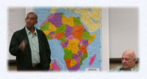
CAPACITY BUILDING FOR LAND POLICY AND ADMINISTRATION REFORM IN AFGHANISTAN (US$820,800)
In June of 2006 Terra Institute, in association with Scanagri Denmark A/S, began work under this Asian Development Bank effort. The purpose of this one year project was to provide Technical Assistance to the Afghan Government in formulating a national land policy and in building a related institutional structure for land administration. The terms of reference specified five outputs.
Output 1: Devise and test a method of community consultation for reaching agreements about legitimate users of pastures and forest land. The Technical Assistance Team developed and successfully tested in representative areas a model for the administration of community range land agreements administered by village Shuras. This approach included mapping of rangeland parcel boundaries on large scale satellite images, preparation of agreements about the legitimate users of these parcels witnessed by the relevant stakeholders, gaining agreement of governmental agencies as to the legitimacy of the village agreements, and the archiving of those agreements and images in village-administered storage cabinets. Rangeland parcel boundaries were digitised and copied into a GIS for incorporation into appropriate spatial data bases and for crossreferencing at levels above the community, such as district, province, and national levels.
Output 2: Assess institutional structures and technical capacity for land administration in Afghanistan. The Team assessed two bodies within the Ministry of Agriculture, Irrigation, and Livestock; an administrative body know as the Amlak and the Natural Resource Management Department, which assumes the important responsibility in rangeland and forest management. In addition they assessed the Cadastral Survey sub department of the Afghan Geodesy and Cartography Head Office. The assessment looked at existing structures for land administration, provided data on the technical and administrative capacity of existing government institutions to carry out functions of land policy and administration, including training and institutional development needs, and provided recommendations on institutional performance enhancement and effectiveness.
The assessment found that all land agencies had to cope with a backlog in their mandated activities. In addition, the mandates of each individual institution were out of synch with the community approach. This was probably not surprising, given how little acceptance inside government there was for devolution of power and the assignment of enhanced responsibilities to communities. There was also a general resistance inside government towards institutional change. As a consequence, all land institutions faced a backlog in capacity for the implementation of community based methods, and accordingly any effort to improve community based methods needed sufficient investments in capacity building programmes. New terms of reference for staff in all offices needed to be devised in order to prepare staff for their new roles as guide, supporter and facilitator of communities in land administration and management.
Cooperation between land institutions was very limited at best. This was not surprising, when it was not clearly defined what the basis of this cooperation should be. Mandates of different institutions needed to be attuned to the community approach and harmonised accordingly.
Output 3: Draft an Action Plan for rural land administration reform in Afghanistan to provide guidance and structure on how to approach the complex issue of introducing institutional change and to arrive at feasible solutions for the land problems of the country.
Output 4: Strengthen the national land policy. An inter-ministerial working group developed a national land policy which received final approval by the cabinet on September 3rd 2007.
Output 5: Recommend amendments to the legal framework for land and land administration in Afghanistan. With the Land Policy Framework now formally in place, revamping the existing legal framework for land has become one of the priorities of the Ministries of Agriculture, Justice and Urban Development. The crucial question now is how to put in place an appropriate land law in conformity with the supreme law of the land and with the land policy.
Building upon its past work in Afghanistan, the Team was able to coordinate closely with past and current related work being undertaken by other aid agencies such as USAID, the World Bank, the Afghanistan Research Evaluation Unit, and the Asian Development Bank in modernizing land policy and administration in Afghanistan.
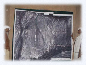
Delineated
satellite imagery was placed
for public display in a village mosque
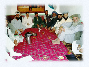
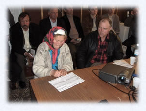
A Meeting of a Village Council (Shura): At the local level, families, clans, and tribes send their representatives to Village Councils, or shuras, to discuss who has access to communal lands during what months of the year
TECHNICAL ASSISTANCE IN AGRICULTURE (MCC-TAA)
WORLDWIDE
Millennium Challenge Corporation (MCC) issued this ID/IQ Award to Terra Institute, in consortium with HTSPE, Ltd. (UK) and PROMAR International, Inc. (US) to provide consulting services to evaluate the technical, economic, and social aspects of project proposals (due diligence) during the compact process with MCC-eligible (or threshold) countries. MCC also seeks short-term consulting services to assist in review and evaluation of technical issues that arise during the MCC compact process, as well as assistance in identifying options for solutions to these issues. Consulting services are also required when MCC hosts expert review panels and workshops for its counterparts in MCC eligible countries. Finally, ongoing oversight, monitoring, and program evaluation will be required.
For this contract, MCC assignments include four broad areas:
1. Rural Infrastructure: Technical, economic, or social assessments of rural infrastructure that is related to agriculture and the rural economy, such as market access road rehabilitation, reservoir, and irrigation schemes for agriculture;
2. Agricultural Productivity: Technical, economic, or social assessments of agricultural productivity and its impact on rural economic growth and poverty alleviation;
3. Agricultural Marketing: Technical, economic, or social assessments of agricultural market chain (production, post harvest, processing, and marketing) support services;
4. Land Tenure: Technical, economic, or social assessments of land tenure (rural or urban) as it relates to economic growth and poverty alleviation.
Specific agricultural fields of expertise to be provided include: rural agribusinesses; agriculture economics; agricultural marketing and demand assessment; land tenure and land market issues; watershed management and reforestation; agriculture input services; applied agriculture research and extension; agriculture cooperatives and association building; agriculture policy; agriculture engineering; and other agribusiness-related assistance.
The Consortium will provide flexible and rapid response to MCC requests for specific services to address MCC needs in the various aforementioned fields, as they arise. Some requests will require work in more than one area, while others will involve only one technical area. The period of performance for such services may range from one day to several months. Services could be in any of the MCC-eligible countries. For detailed information on these countries, please visit the MCC Web site at www.mcc.gov. This award is for a period of one year with four option period years.
PROJECT (LTERA) (US$2,825,495)
In October of 2004, Terra Institute entered into a subcontract agreement with the Emerging Markets Group, Ltd. to implement this project. The goal of the economic restructuring element of the project was to privatize state owned enterprises and excess land and EMG undertook this task. Terra Institute undertook the land titling and registration component.
At the time, land allocation and uncertain property rights were seen as major blocks to economic development. It was felt that increasing tenure security would provide a path toward economic development. An important priority in the project was to improve the tenure security of people holding land and buildings in the informal settlements which have sprung up in and around the major cities, particularly Kabul. The second priority was to improve governmental capabilities,
enabling the extension of these titling efforts to smaller cities, as well as to the rural areas of Afghanistan.
Terra’s overall goal was to assist the Government of Afghanistan in alleviating the uncertainty surrounding land titles through secure, accessible and efficient property registration; simplification of land-titling procedures; regularization of properties in informal settlements; and clarification of the legal framework supporting property rights—all of which would help market reforms to promote sustainable economic growth and to protect the rights of the poor and improve their livelihoods.
Originally the dominant attitude within the government of Afghanistan was that the informal settlements should be bulldozed to build “modern infrastructure.” Terra’s personnel worked closely with senior government officials to reconcile extremely divergent attitudes, resulting in a new dominant view that the informal settlements should be upgraded and the residents’ tenure security be improved.
In addition to work in the informal settlements, Terra’s team completed reorganization and rehabilitation of 17 of the 34 Makhzans, the offices where historic property records were stored. Afghans were trained so that they can complete the process in the remaining 17 Makhzans. In addition the Afghan Geodetic and Cartographic Head Office is now capable of making aerial digital photographs to potentially be linked to deeds.
Terra also initiated the concept that the government needed to articulate its land policy prior to legislatively dealing with land tenure issues. A first draft land policy was used as a starting point for the methodology developed and tested in the informal settlements. This tested policy resulted in government policy statements and formed part of the comprehensive national land policy. Terra regards this result as one of its most important contributions to the project.
Terra’s Land Titling Team Leader/Legal Advisor Dr. Yohannes Gebremedhin provided full time, long term assistance to LTERA from September 2004 through September 2007. Terra also provided several short term technical assistance teams providing expertise to their local counterparts in the areas of Spatial Information and Mapping, Information Technology, Land Tenure, Registry Operations, Legal and Policy Development, Dispute Resolution, Community Outreach, and Public Awareness.
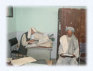
Law clerks copying title deeds by hand in Kabul's registration court
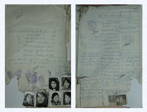
Two examples of a land titling document from the Makhzan in Kabul
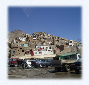
An informal settlement on a hillside in Kabul, Afghanistan
GEORGIA
LAND MARKETS DEVELOPMENT PROJECT (US$8,122,796)
April
2001 – July 2005 Under a Cooperative Agreement with the United
States Agency for International Development (USAID) Terra Institute began it’s collaboration with the Association for the Protection
of Land Owner’s Rights (APLR). The original objectives were:
• Registration of an additional 1,400,000 parcels (for a total
of 2,400,000 total since July 1999) and issuance of registration certificates
to landowners that ensure secure title;
• Provide support for land transactions that lead to land market
development;
• Provide public education and support to landowners to ensure
the protection of their land rights;
• Provide support and assistance for further land privatization,
including enterprise
land;
• Advise on legal land reform and monitoring new land law introduced
by Government of the Republic of Georgia;
• Strengthen the APLR’s administrative and financial management
capacities for
managing initial registration, land market policy development, public
education concerning landowners’ rights and responsibilities,
and the promotion of security of rights to land and real estate through
registered transactions.
• Conversion of the APLR and other organizations into Self Regulating
Organizations which will include other groups or professionals related
to real estate transactions, cadastral surveying, property appraisal,
auction, and land registration services;
• Conduct foreign donor liaison;
• Report on project progress and other issues to USAID and other
appropriate authorities.
• Establish a legal mediation and conflict resolution capability
in the APLR. In June, 2003, a two year extension of this project was
initiated with the general goal of imiproving the operations of land
markets, particularly agricultural land markets. The objectives of the
extended project were to:
• Complete a “quality assurance” program for the initial
registration of agricultural reform land
• Develop, test, and revise regulations for implementing the law
for the privatization of remaining State owned agricultural land, including
the initial registration of agricultural land previously privatized
but not registered (the “white spots” on the initial registration
maps);
• Develop the real estate market institutions, by
-
strengthening the policy voice of the APLR,
-
increasing the services of the APLR for assisting land owners,
-
Improving the legal/policy framework for the proper functioning of land markets.
Agricultural land in Georgia registered
under the GLMDP